Geology
101
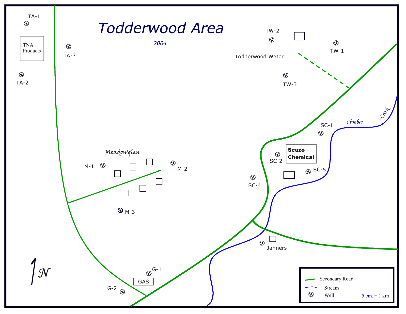
Todderwood Area Groundwater Study
Introduction: This laboratory will introduce you to groundwater contouring and isoconcentration mapping. You will use these skills along with your knowledge of hydrogeology to solve a groundwater contamination scenario that mimics situations throughout the world.
Situation: You
are geologists hired by the city of
The major chemicals of concern are trichloroethylene (TCE), Toluene, and Benzene. TCE is a high density organic compound that was a commonly used degreaser in many manufacturing processes from WWII through the 1970’s. Toluene and Benzene are volatile organic compounds which were used in many processes, but are also the breakdown products of other chemicals. They are major constituents of gasoline.
Process:
- Construct a groundwater contour map using the data table and one of the blank maps. Groundwater contours follow the same rules as land contours and differ only in that they represent the contour of the water table.
- Construct isoconcentration maps for each of the major chemical pollutants indicated on the data table. Isoconcentration lines generally use the same rules as contours with the following exceptions:
- Pollutants are “blips” located around the source. A single map may have more than one set of lines that are potentially isolated from each other;
- Isoconcentration lines do not have a set contour interval; you may pick any number for a line that makes sense;
- You can infer the shape of an isoconcentration line using the flow of groundwater;
- Remember when drawing isoconcentration lines that you have some sense of where the pollutant entered the ground
- On your groundwater flow map, lightly draw 2-3 flow lines to give you a general sense of groundwater flow in the area
- Based on the flow map and the isoconcentration map, who is likely responsible for the TCE contamination at Meadowglen’s wells? How do you know?
- Is the responsible party you identified in #2 responsible for contaminating any other wells? Is their contamination affecting any ecologically sensitive areas? If so, explain.
- Describe and suggest an explanation for the contamination around the gas station.
- Describe and suggest an explanation for the contamination at the Todderwood Water well field.
- You will notice that many of the contaminants decrease in there concentrations as they move down gradient. What are the reason(s) for this?
- Based on the reading in section 12.5 of your text, are there any health risks in the area? What are they? Elaborate.
- If you identified any risks, what remedial action should be taken? Who should pay for the cost of remediation?
- Explain in a short paragraph what you have learned from this laboratory.