The Quest for Water Polar Ice Caps General Info
Ground Water
The possibility of organisms living on mars is supported by the existence of ground water. There are types of bacteria that thrive here on earth, living underneath the earths surface, drawing water from the ground around them. If we were able to warm the surface of mars by just even a slight amount, the frozen water beneath the surface would turn liquid, providing adequate amounts to support the first bacteria.
|
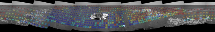
This image shows the discovery of hematite, a mineral commonly associated with the presence of water. The dots show where hematite was found, supporting the belief that ground water might exist on mars. Red dots represent areas where hematite was around 20 percent and blue dots show where the presence of hematite was little or non-existent. This photo was taken by NASA's Mars Exploration Rover OPPORTUNITY from the landing area. |
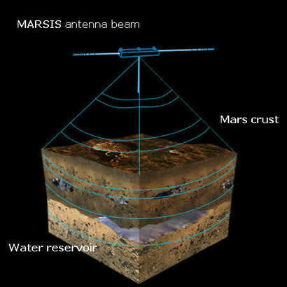
Already the European Space Agency is proposing to the idea of sending MARSIS, or Mars Advanced Radar for Subsurface and Ionospheric Sounding, to use ground penetrating radar which will search for, and map, any underground water reservoirs. On board ESA's Mars Express, MARSIS will emit low frequency radar waves from a 40 meter long antenna while Mar's Express orbits the planet. Analysis of the data will provide information about the planets top five kilometers of the Martian crust, including the possibility of stored water.
The Mars Express will also include several other instrument designed to specifically further our understanding of water on Mars. Four instruments will be specifically designed to study the Martian atmosphere in hopes of providing a better understanding of how water vapor, and other atmospheric gases escape from Mars into space. These instruments include ASPERA, SPICAM, PFS and MaRS. Another two instruments, HRSC and OMEGA are designed to study the planets surface to learn where water may have once existed, or still exists underground. For further information about the Mars Express mission or the European Space Agency, check out the connecting links.
European Space Agency Mars Express mission
The Map below shows the northern
hemisphere of mars with areas color-coded the show the possible presence of
frozen ground water. Gamma rays from the element hydrogen, mainly in the form of
water ice, were used to create this image. Violet and blue represent areas
where there is a high concentration, and red represent the area with the least
amount of
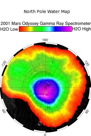 content. The great concentration at the very north, or center of the
map, can be explained by the polar ice cap, and the remaining plume represents
frozen water with in the surrounding ground. (This image was provided by the
Mars Odyssey Orbiter in
2002)
content. The great concentration at the very north, or center of the
map, can be explained by the polar ice cap, and the remaining plume represents
frozen water with in the surrounding ground. (This image was provided by the
Mars Odyssey Orbiter in
2002)
For more information on the Odyssey mission, check out this video Odyssey Mission
A future mission to Mars is currently being planned to explore Mars's artic plains in search of evidence of frozen water, and other organic molecules. This mission is scheduled to launch in August 2007. Check out the Phoenix mission at NASA's Phoenix Mars Lander 2007
Remains of channels, believed to be carved by water, appear to lead to the northern half of the planet, supporting the idea that a great ocean once covered a large portion of the northern hemisphere. If this were the case, this might account for the finding of this large plume of frozen ground water surrounding the northern pole. Even in the southern portion of the planet, the ancient presence of water still lingers. Interconnecting valleys in the southern highlands support the idea that water was once common in these areas. And often, at high latitudes, craters bear the mark of what is known as fluidised ejecta, more easily described as resembling the debris ring around a stone dropped in soft mud. All these features support the idea that water was once present on the surface of Mars in liquid form, so perhaps, one day it will be present again
If we hope to achieve a therefore Mars, we will need to somehow provide the planet with an adequate source of water. The idea that water may in fact be present already beneath the surface, within the frozen ground, brings hope that with some effort the planet can be warmed and liquid water will flow once more. Only when this is achieved can we hope to sustain life, in any form, on the surface of this neighboring planet.
|
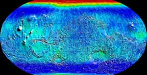
Epithermal neutron imaging provides the most sensitive recognition of hydrogen in surface soils, associating that region with the presence of frozen water. This image show a high concentration around the north pole, with large field across the equator. "the northern ring coincides with a region of high albedo and low thermal inertia, which are both required for near-surface water ice to be stable at latitudes equatorward of about positive/negative 60 degree latitude" (NASA) |
Thermal neutron imaging shows subsurface deposits of hydrogen and the surface presence of Carbon Dioxide. There is a heavier concentration of carbon dioxide at the northern pole, and only a slight dusting in the southern pole.
|