Evolution of Earth Systems
El Niño Southern Oscillation
The following activity is designed to facilitate the discovery of the El Nino phenomena and it’s effects. Outcomes are as follows:
- Critically analyze actual El Nino data in order to determine the cause and effects of the phenomena
- Learn the nature of El Nino while actively manipulating data and maps
- Interact with students partners to fully comprehend the subtleties of the data and their ultimate meting
- Communicate their understanding in a large group discussion and in writing
1. Log on to your computer, load a web browser, and go to the following site:
then click SSD Highlighted Products
then click SST Anomalies
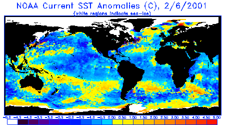
2. The following are
maps of monthly sea surface temperature (SST) anomalies constructed from
satellite data on ocean height. An
anomaly is a variation from the mean (average).
That is, it is the average value subtracted from current measured
value. In the case of monthly SST
anomalies, it is the mean SST for a given month subtracted from the SST for the
month currently being studied. For
example, if the SST for June 1996 off the coast of
3. Go to the year 1997, begin with January, and view the maps for every month during that year. Locate areas of the world where strong anomalies seem to “grow.” Continue into 1998 until the anomalies you find disappear. Where do the anomalies appear?

When do they begin and when do they end? How extreme do the anomalies get? Document your findings.
4. Pause for a class discussion.
5. Next, go to the following site:
http://www.pmel.noaa.gov/tao/jsdisplay/
6. This is data from
the TAO array of buoys. Click on Lat
Lon plots, monthly, and bring up February 1997. Enlarge it so it is easy to view. Notice that the top image is means, while the
bottom is anomalies. The means are
actual average temperatures for that month.
Anomalies are as stated previously.
The image is the equatorial
7. Load an image for November 1997. Respond to the questions below.
- Explain the differences between the means versus the anomalies on the TAO image. Which one is preferable for visualizing the El Nino event?
- Do either of the two anomaly maps (Feb. vs. Nov.) show any extreme conditions? Which one?
- Compare the two sets of maps. How do temperatures vary between February and November? Cite multiple specific examples.
- Where do they vary the most?
- How do wind directions change?
- What do the wind roses (arrows) on the anomaly maps depict?
- What major wind belt is active at this latitude? How do prevailing winds change from one map to the next? How might the prevailing wind directions affect an El Nino event?
8. Finally, Load the most current image. Are we experiencing an El Nino or La Niña now? Compare this image to several images from previous months. Are there any trends? Might we be heading toward an El Nino / La Niña event?
9. Reflect on your learning. What new insights have you gained as a result of completing this activity? Explain in a detailed paragraph.